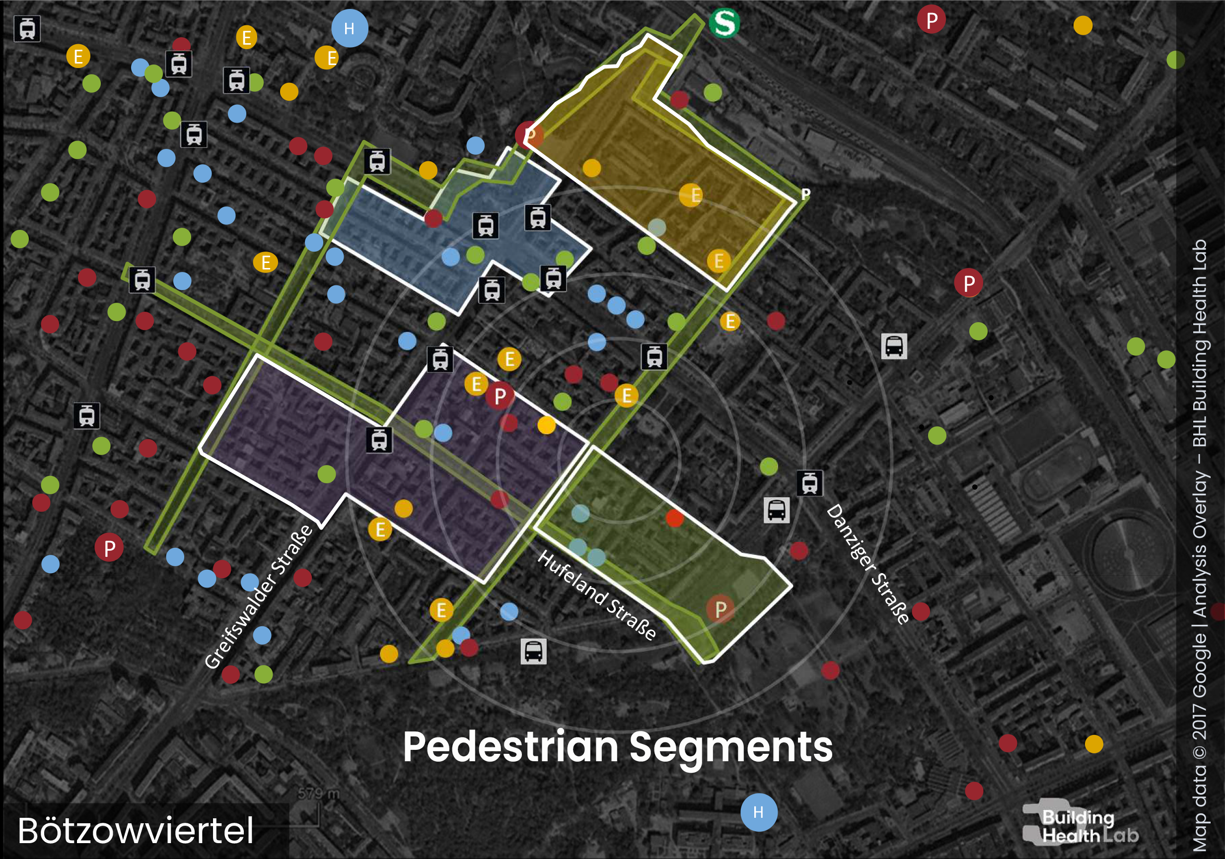
UrbanCare Concept
Positioning spatial inequity as a strategic lens for linking street-level evidence to city-scale transformation.
The UrbanCare Concept positions spatial inequity as a structuring condition for understanding how urban health risks and opportunities emerge, accumulate, and can be addressed. By focusing on street-level conditions experienced along everyday pedestrian routes, the framework enables the assessment of cumulative health burdens, climate-related stresses, and patterns of economic inefficiency that are often obscured at coarser spatial scales. This fine-grained approach makes visible not only risks, but also concrete opportunities for intervention, supporting the development of evidence-based and sustainable solutions that can be aligned, scaled, and integrated at the city level.
Who: Priority Groups
UrbanCare prioritizes slower-paced groups as a methodological lens for understanding where urban systems fail under real-world conditions. These users are not defined by age, disability status, or identity categories, but by functional characteristics of movement such as reduced walking speed, limited maneuverability, or delayed transitions when stopping, turning, or crossing. These traits increase physical effort, prolong exposure to environmental stressors, and reduce autonomy when navigating fragmented or stressful urban environments.
By shifting attention from who people are to how they move, UrbanCare reframes equity as an experiential condition shaped by gait, effort, and spatial agency. Slower-paced groups experience the highest cumulative burden at critical urban scenes where design variables interact with biomechanical constraints. Centering analysis on these users allows UrbanCare to identify the most consequential weaknesses in urban systems and to use their experience as the benchmark for health-supportive and climate-resilient urban design.
Why: Spatial Inequity at Street Level Informs City Plans
UrbanCare treats spatial inequity as the compounded effect of mobility constraints and climate-related stressors acting across everyday walking circuits. These effects accumulate most clearly at the street level, where effort increases, dwell time extends, and exposure dose intensifies for slower-paced users. Aggregated city-wide indicators often conceal these dynamics, masking both the severity of local burdens and the opportunities for targeted intervention.
By focusing on street-level conditions, UrbanCare produces pedestrian evidence for sustainability that links scene-scale design features to measurable impacts on health, climate resilience, and economic efficiency. This approach reveals where small, well-targeted interventions can yield disproportionate gains, reduce risk shifting, and improve implementation capacity across departments. Street-level analysis is therefore not a local exception but a strategic entry point for informing coherent, evidence-based city plans and policies.
What: Mitigation Targets for Healthy Urban Environments
To make spatial inequity observable and actionable, UrbanCare defines four canonical mitigation targets that converge where pedestrians slow down, wait, or reroute: walkability, surface runoff, urban heat, and biotope loss. These targets are selected not in isolation, but because together they structure the conditions that determine effort, exposure dose, and spatial agency for slower-paced users.
Walkability addresses path continuity and block connectivity, shaping the physical and cognitive effort required to move through the city. Surface runoff reflects permeability and drainage conditions that affect safety, stability, and contamination at walking lines. Urban heat captures thermal stress driven by material properties, shading, and airflow. Biotope loss describes the degradation of vegetated systems that support cooling, water regulation, biodiversity, and psychological restoration. Assessed together, these targets link scene-scale design variables to the quality of air, soil, and water that underpin human health.
Each mitigation target is developed in a dedicated lecture outlining assessment methods, spatial indicators, and design pathways. The four lectures provide a framework for evaluating exposure and structuring evidence-based street-level responses.
Walkability
Promoting active travel while reducing exposure to mobility barriers and sedentary health risks.
Surface Runoff
Restoring urban water cycles and managing flood risk through unsealing, permeable surfaces, and nature-based solutions.
Urban Heat
Mitigating urban heat islands to protect vulnerable groups, improve outdoor comfort, and reduce energy demand.
Biotope Loss
Restoring biodiversity and ecological continuity across urban environments to support healthier urban ecosystems.
Where: Pedestrian Loops and Urban Scenes
UrbanCare formalizes pedestrian environments through a nested spatial unit composed of Pedestrian Loops and Urban Scenes. Pedestrian Loops are everyday walking circuits of approximately two kilometers that reflect the scale of daily mobility and exposure, particularly for slower-paced users. They capture how stress accumulates across connected streets rather than at isolated points.
Within these loops, UrbanCare identifies four recurring Urban Scene types where movement typically slows, pauses, or reroutes: stops and stations, street crossings, respite areas, and priority entrances. These scenes concentrate effort, exposure, and risk, making them critical locations for diagnosing spatial inequity. By anchoring analysis to these human-scale settings, UrbanCare ensures that assessment and intervention are grounded in lived experience and remain comparable across sites.

Pedestrian Loops
Pedestrian Loops are everyday walking circuits, typically around two kilometres in length, that structure how pedestrians experience movement, effort, delay, and access across real urban environments. Rather than isolated paths, loops are composed of interconnected street segments and recurring urban scenes that together determine safety, comfort, accessibility, and climate exposure, particularly for slower-paced and vulnerable users. By capturing path continuity, environmental protection, and connectivity to essential destinations, Pedestrian Loops provide a replicable and comparable unit for assessing spatial inequity and cumulative stress at the scale of lived pedestrian experience.
Stops & Stations

Waiting areas and immediate approaches to bus, tram, and metro services. These scenes concentrate dwell time and exposure, particularly to heat and weather stress, making priority legibility, shade, seating, and thermal comfort critical for slower-paced and vulnerable users. Stops and stations function as nodal points within the urban mobility network; deficiencies at these locations propagate impacts that may decrease public transportation ridership across the city.
Street Crossings

Crossing points and their approaches, shaped by curb geometry, sightlines, signal timing, and turning movements. These scenes concentrate conflict risk and time pressure, especially for slower-paced pedestrians, and require predictable staging, sufficient crossing time, and a clear, legible right of way. Deficiencies at crossings compromise route safety and efficiency by propagating risk, exposure and delay across broader mobility systems citywide.
Respite Areas

Small-scale locations that allow physiological and psychological recovery while walking, such as benches, shaded pockets, drinking fountains, public toilets, and quiet spaces. These scenes reduce cumulative effort and exposure, with design variables including seating availability, spacing, shade, and barrier-free access. The lack of respite areas or poor-quality provision restricts restrict effective walking range, propagating accessibility limitations across the city scale.
Priority Destinations

Thresholds to essential daily destinations such as parks, schools, libraries, healthcare facilities, pharmacies, plazas, and community services. These scenes concentrate waiting and transition effort and therefore require step-free access, legible approaches, and shaded, seated queue management where exposure accumulates. Inadequate design constrains service catchment areas, reducing system-wide participation in essential services at the city scale.
How: Organizing Complexity Through the UrbanCare Matrix
UrbanCare organizes urban health complexity through a matrix that aligns objectives across spatial scales, planning phases, and urban conditions.
The matrix structures analysis at two spatial scales, neighborhood and street, and distinguishes between urban structures and urban dynamics. This dual reading enables UrbanCare to address both the physical configuration of the built environment and the processes through which spatial inequity is produced and reinforced over time.
At the city and neighborhood levels, the matrix supports the establishment of baselines and strategic guidelines that identify where spatial inequity accumulates for slower-paced and vulnerable groups. These baselines inform planning objectives by defining outcome directions in a defined order: improving walkability, managing surface runoff through unsealing, mitigating urban heat through targeted shading, and restoring biotope functioning as a final step. At this stage, the matrix ensures that equity and resilience principles are embedded before spatial solutions are specified.
At the neighborhood and street levels, the matrix translates strategic objectives into spatial rules and specifications. Structural assessments of pedestrian loops and urban scenes inform design objectives that define the physical conditions required to meet equity thresholds for slower-paced users. In parallel, dynamic processes such as mobility flows, runoff behavior, thermal exposure, and ecological continuity are analyzed to guide mitigation strategies that address temporal and situational burdens in alignment with the defined intervention sequence.
The UrbanCare Matrix enables traceability across research, planning, and design phases by linking city-level intent, neighborhood prioritization, and street-scale specifications within a single framework. It ensures that evidence collected at streets and urban scenes informs higher-level decisions, while strategic goals remain verifiable through measurable performance at street and scene levels. In this way, the matrix functions as a methodological backbone that connects spatial equity, climate resilience, and implementability within a coherent urban health framework.
Source:
The UrbanCare Concept and theoretical framework presented on this page are derived from the doctoral thesis:
UrbanCare: An Evidence-Based and Participatory Framework for Health-Centered, Climate-Resilient, and Financially Viable Pedestrian Projects,
by Alvaro Valera Sosa, 2025.