UrbanCare Workflow
A project cycle connecting city goals to neighborhood priorities and street-level action.
The UrbanCare project cycle connects city goals to neighborhood priorities and street-level action.
Across the Research, Planning, and Design phases. A matrix is used to align spatial scales, project development phases, and urban conditions, structuring how urban structures and dynamics are assessed and addressed through an ordered sequence of intervention: walkability, surface runoff, urban heat, and biotope loss.
Within this workflow, the matrix ensures that evidence gathered at streets and urban scenes informs planning decisions, while strategic objectives remain measurable and actionable across phases. It provides the operational structure through which urban health intent is translated into implementable, climate-responsive, and resilient spatial solutions.
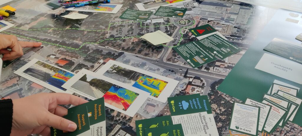
Research Phase: Establishing the Urban Health and Climate Baseline
This phase defines the starting point for each case study site.
Researchers analyze the existing urban and environmental conditions using ecosystem indicators on walkability, surface runoff, urban heat, and biotope loss.
The results identify vulnerable areas, slower-paced groups, and baseline data to support future planning and design actions.
Overview
The Research Workspace provides Survey123 forms for registering existing datasets from recognized open sources that comply with Open Data licensing and EU INSPIRE metadata requirements, as well as for uploading new data relevant to each case.
The phase is organized around a five-box matrix that spans multiple urban scales, focusing on key aspects of the baseline assessment from city-scale structures to street-level dynamics.
Boxes Preview
Box 1: City Baseline
Box 2: Neighborhood Structures
Box 3: Neighborhood Dynamics
Box 4: Street Structures
Box 5: Street Dynamics
Planning Phase: Goal Alignment for Health, Climate, and Economy
Building on the baseline results, this phase develops integrated spatial strategies.
The Planning Phase fosters collaboration among stakeholders to align health, climate, and economic objectives through Community Dialogues and Stakeholder Workshops.
Findings from the Research Phase and insights from the Data Viewer guide decisions on where and how interventions can best improve public health outcomes and urban resilience.
Overview:
In the Planning Workspace, users will find three Planning Posters that open the corresponding Planning Dashboards.
Each dashboard includes Survey123 forms to help tailor planning boards and create strategies based on local priorities.
The Planning Posters represent the progressive steps that translate research insights into design targets aligned with health, climate, and economic outcomes.
Design Phase: From Strategies and Targets to Spatial Solutions
The design phase converts planned targets into detailed spatial interventions.
Here, each workspace focuses on applying mitigation targets to ensure technical and spatial performance meet the planned health and climate outcomes.
Users can test scenarios, visualize impacts, and refine solutions for implementation.
Overview:
The Design Workspace uses the Data Viewer to explore Pedestrian Loops and Urban Scenes evaluated in the Research Phase. In this phase the Dta Viewer includes a Design icon, allowing access to downloadable CAD or point-cloud files for further development in external design software.
Completed designs can be uploaded through Survey123 to appear live within the Pedestrian Loop, connecting spatial proposals directly to the research and planning phases.
Source:
The UrbanCare framework and workflow presented on this page are derived from the doctoral thesis:
UrbanCare: An Evidence-Based and Participatory Framework for Health-Centered, Climate-Resilient, and Financially Viable Pedestrian Projects,
by Alvaro Valera Sosa, 2025.